

AustraliaAS 3959:2018

Determine Bushfire Attack Level (BAL) for building sites to AS 3959:2018. Supports both simplified and detailed calculation methods using fire danger index, vegetation classification, distance, and effective slope.
The Calcs.com Bushfire Attack Level calculator allows the user to quickly find the BAL for any site in Australia with just five simple inputs, using both the simplified method and the detailed method (AS3959: Appendix B) simultaneously.
Signing up for a Calcs.com account will unlock further advanced features for design and analysis of beams and a variety of other structural elements. Calcs.com enables design in steel, concrete and timber, according to Australian, US and EU Standards.
The sheet is divided into four main sections:
- ‘Key Inputs’, where all of the required inputs are entered.
- ‘Advanced Parameter Overrides’, where advanced users may enter overrides for values used in the detailed (Appendix B) method, such as ambient temperature, flame width and emissivity, and elevation of the receiver.
- ‘Summary’, where the calculated Bushfire Attack Level is displayed, along with information about the design considerations that the given BAL requires. If a simplified method calculation is valid, then maximum distances to the vegetation for each BAL are also shown in tabular form.
- ‘Detailed Method Results’, where calculated values of interest to advanced users are displayed, including the forward rate of speed, flame angle, view factor, and radiant heat flux.
Method & scope
Symbols
These are the symbols shown in the calculator, with the label the app gives each one.Calculation method
The Bushfire Attack Level calculator determines BAL for a site per AS 3959:2018. BAL quantifies the radiant heat flux exposure from bushfire to which a building may be subjected, expressed as a level that maps directly to construction requirements.Simplified method (AS 3959:2018, Tables 2.4.2 and 2.4.3)
The simplified method looks up BAL from AS 3959:2018 Table 2.4.2 (for sites in FDI 80 fire weather regions) or Table 2.4.3 (for sites in FDI 100 fire weather regions). Inputs are:- FDI, Fire Danger Index for the region (80 or 100), derived from AS 3959:2018 Figure 1.5 or the relevant state government authority
- Vegetation class, Grassland, Scrub, Shrubland, Mallee/mulga/heath, Rainforest, or Forest
- Distance, horizontal distance in meters between the site and the nearest edge of classified vegetation
- Effective slope, slope under the vegetation in degrees (upslope increases fire intensity; downslope decreases it)
Detailed method (AS 3959:2018, Appendix B)
The detailed method calculates the radiant heat flux (kW/m²) at the site directly from fuel and weather parameters using the McArthur fire spread model:- Fuel age and fuel moisture content, derived from climate data or entered directly
- Wind speed at 10 m height, from the design fire weather scenario
- Ambient temperature and relative humidity, from the design weather event
- Fuel heat of combustion, for the vegetation type
BAL thresholds and construction requirements
The calculator reports the governing BAL and the applicable AS 3959:2018 section, so construction specifications can be drawn directly from the result.
How to use it
1
Open the calculator
Open it from Run calc in the About this calculator panel above. You can also choose Add New Calculation in a project and select Bushfire Attack Level under Loads.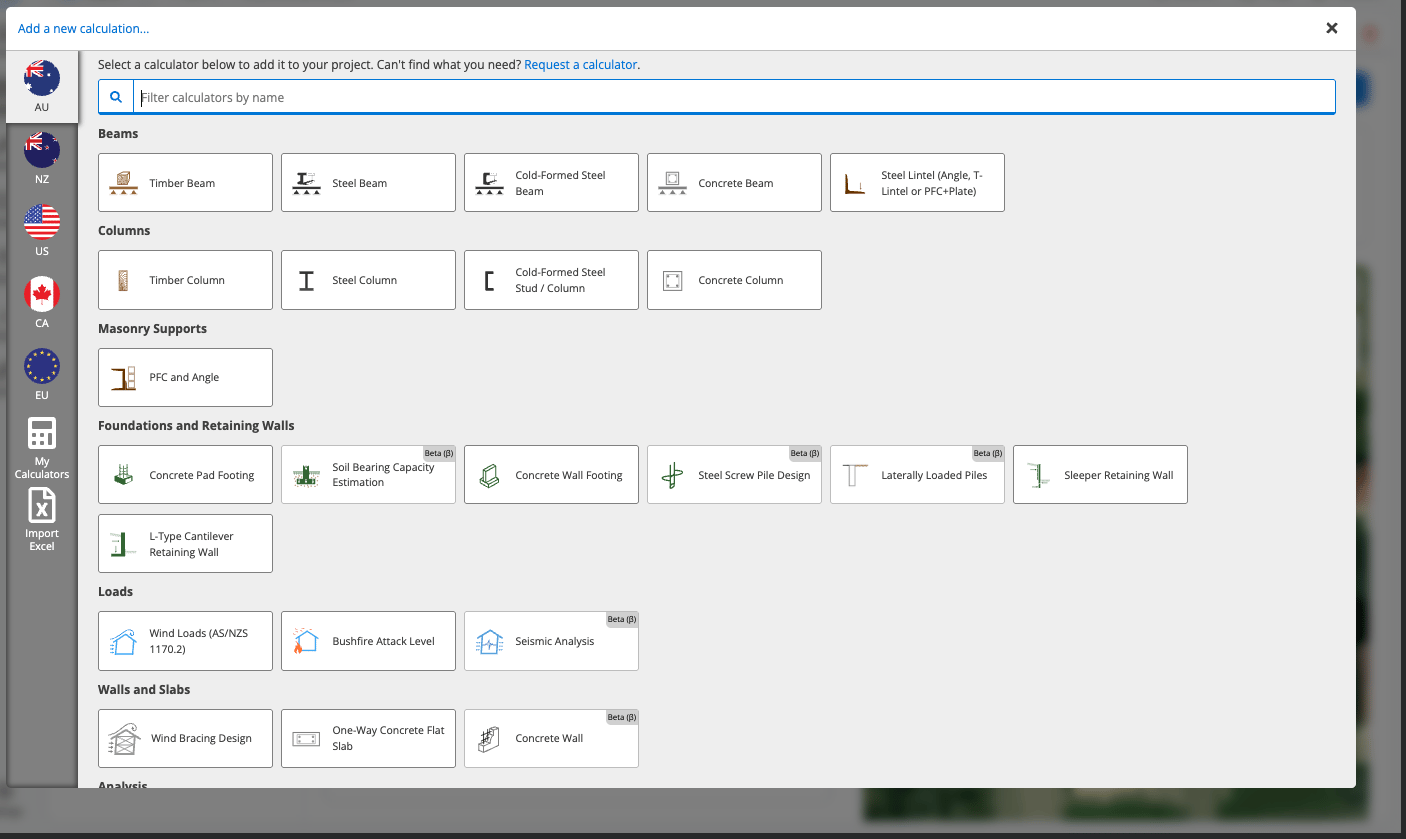
2
Choose the calculation method
Key Inputs starts with the Calculation Method. Choose Simplified (AS 3959, Cl 2) or Detailed (AS 3959, App. B).Click any input label to see its reference explanation, clause, conditions and assumptions. See Checks, References, Conditions and Assumptions.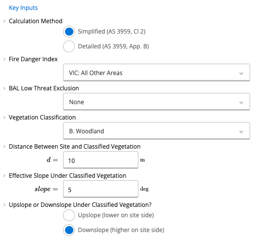
3
Select the Fire Danger Index
Select the Fire Danger Index region relevant for your design. The dropdown lists the regions by name, and you can type in it to filter the list. If your local council or region requires a different Fire Danger Index, choose “Custom (Detailed Method Only)” and manually input an FDI value. It is available only with the Detailed method.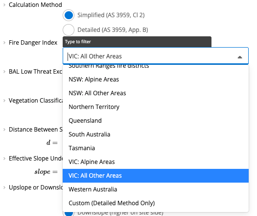
4
Check the low threat exclusion
Review the BAL Low Threat Exclusion options and select one if it applies. These will only apply if vegetation is particularly far away, in small or narrow patches, or of a “low-threat” type (such as maintained lawns). The options are None, then: a) Vegetation >100 m away, b) Single isolated vegetation area <1 ha in area, c) Multiple isolated vegetation areas <0.25 ha each, d) Vegetation strip < 20 m in width, e) Non-vegetated areas, and f) Low-threat vegetation.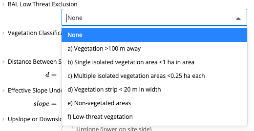
5
Select the vegetation classification
Select the type of vegetation to be classified: A. Forest, B. Woodland, C. Shrubland, D. Scrub, E. Mallee / Mulga, F. Rainforest or G. Grassland / Tussock Moorland.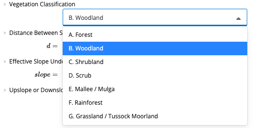
6
Enter the distance and the slope
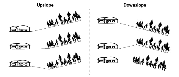
Enter the distance (m) between the site and the classified vegetation being tested in this analysis. A more complete description for exactly how this should be measured is available by clicking on the label and/or referring to the standard at the cited clause, though in general this measurement is the horizontal distance from an outer wall to the understory of the vegetation.Enter the effective slope (deg) of the ground under the classified vegetation. Again, refer to the description and/or standard for more detail, but this generally means the highest notable ground slope within the vegetation area. Note that if a negative value is entered here, then the “Upslope” radio button will automatically be selected, though the radio button may alternatively be manually changed. Choose Upslope (lower on site side) or Downslope (higher on site side). A vegetation area is “Upslope” if its elevation is lower on the site side of the vegetation (see diagram). The slope between the site and the vegetation does not affect whether it is “Upslope” or “Downslope”.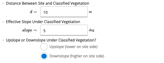
7
Set the site slope
In the simplified method, the slope between the site and the vegetation, referred to as the Site Slope, is assumed to be the same as the Effective Slope Under the Classified Vegetation. If this is not the case, however, then the Site Slope may also be changed. With the Detailed method selected, Key Inputs shows a Site Slope row with an Override Value and a Value for Computation (both in deg), and the Site Slope will affect the results of the detailed (Appendix B) method.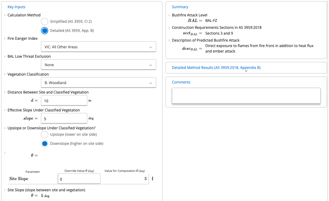
8
Override the advanced parameters
Most users can simply ignore Advanced Parameter Overrides for Detailed Method (AS 3959:2018, Appendix B), though advanced users may wish to override parameters of the detailed (Appendix B) method calculations: Ambient Temperature (K), Relative Humidity (%), Flame Width (m), Flame Emissivity, Flame Temperature (K) and Height of Receiver (m). Each row has an Override Value and a Value for Computations, and the Height of Receiver shows “(optimised)” as its value for computations. Please refer to the descriptions for each value and/or the AS 3959 clause cited for each override for details on what exactly each means. Changing any of these values will result in the simplified method no longer being valid, and the associated results disappearing from the Summary section on the right side of the page. Clearing an input box will result in the default simplified method value being used for the parameter. The Simplified Method Valid? row shows whether the simplified method is valid.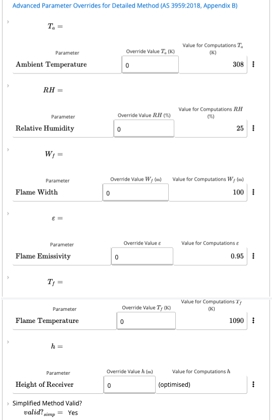
9
Read the summary
The Summary shows the Bushfire Attack Level, the Bushfire Attack Level Distance Limits (the distances in m for BAL-FZ, BAL-40, BAL-29, BAL-19 and BAL-12.5), the Construction Requirements Sections in AS 3959:2018 and the Description of Predicted Bushfire Attack.The important results of a BAL classification are the construction requirements sections that are triggered. Therefore, the section numbers required by the calculated BAL are shown following the actual BAL, along with the standard’s Description of Predicted Bushfire Attack which can occur at the calculated BAL. The distance limits table is not displayed if the simplified method is not valid (such as if a custom FDI was used, or if any of the Advanced Parameter Overrides were set).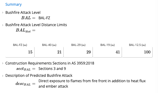
10
Open a result to see its clause
Click a result label to open its Formula Reference, References and Equation. With the Simplified method, the Bushfire Attack Level result is labelled BAL_simp and cites AS 3959:2018 Tables 2.4, 2.5, 2.6 and 2.7. With the Detailed method it cites AS 3959:2018 Table 3.1 and Cl B1, as in the screenshot below. Select the clause button under References to read the clause from AS 3959:2018 inside the calculator. See Viewing Clauses from Inside a Calculator.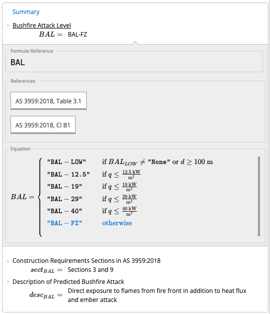
11
Check the detailed method results
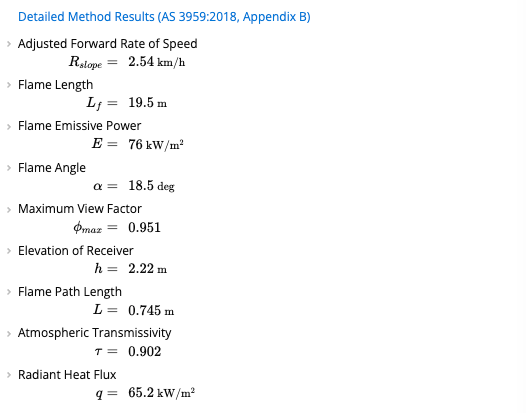
Below the Summary, advanced users may click on the Detailed Method Results heading to see the results for the Appendix B calculations performed. These results include the following:
- Adjusted Forward Rate of Speed: The speed at which flames may advance on the site, adjusted for the Effective Slope. This is dependent upon many factors, including the type and quantity of fuel present, as well as climatic factors such as wind speed and humidity.
- Flame Length: The total length of the flame which may occur, dependent upon the type and quantity of fuel present, as well as the forward rate of speed.
- Flame Emissive Power: The energy power put out by a unit area of the flame, dependent primarily upon the flame temperature.
- Flame Angle: The angle at which the flame may form. This value is determined through an iterative solving process defined in the standard, and which may be referenced in the collapsed sections on the left side of the page.
- Maximum View Factor: This essentially refers to how much of the flame will be in direct ‘view’ of the site, and therefore how much of the flame’s heat will affect the site. It is found through the same iterative process as the Flame Angle.
- Elevation of Receiver: This value may be overridden manually, but if it is not, then the worst-case elevation is found through the same iterative process as the Flame Angle.
- Flame Path Length: The length along the ground which may be burning as the flame advances toward the site, dependent upon the Flame Angle, Flame Length, and Distance to Classified Vegetation.
- Atmospheric Transmissivity: The proportion of the flame’s heat which transmits through the atmosphere to the site. This value is based upon empirical testing and dependent upon the Ambient Temperature, Flame Temperature, Relative Humidity, and Path Length.
-
Radiant Heat Flux: The amount of heat which will reach the site, per unit area of the site. This value is compared with the various limits to determine the Bushfire Attack Level (for example, “BAL-29” means that up to 29 of heat flux will reach the site).
Common questions
What standard does this calculator follow?
What standard does this calculator follow?
The calculator implements AS 3959:2018, Construction of buildings in bushfire-prone areas. It determines Bushfire Attack Level (BAL) using either the simplified method (Tables 2.4.2 and 2.4.3) or the detailed method (Appendix B). The BAL result directly determines which construction requirements in Sections 3 through 9 of AS 3959:2018 apply to the building.
What are the key inputs?
What are the key inputs?
Key inputs are calculation method (simplified or detailed), Fire Danger Index (FDI) for the region, vegetation classification (Grassland G, Scrub S, Shrubland H, Mallee/mulga M, Rainforest R, Forest F, or no vegetation), horizontal distance between the site and the classified vegetation boundary, and effective slope under the classified vegetation.
What does the calculator output?
What does the calculator output?
Outputs include the Bushfire Attack Level (BAL-LOW, BAL-12.5, BAL-19, BAL-29, BAL-40, or BAL-FZ), the applicable AS 3959:2018 sections for construction requirements, and a description of the predicted bushfire attack for the site. The result is provided for each classified vegetation type present on or near the site.
What is the difference between the simplified and detailed methods?
What is the difference between the simplified and detailed methods?
The simplified method uses tabulated FDI, vegetation type, distance, and slope look-up tables (AS 3959:2018 Tables 2.4.2 and 2.4.3) to determine BAL directly. The detailed Appendix B method calculates flame height and heat flux from first principles using fuel moisture, wind speed, ambient temperature, and relative humidity, which can sometimes produce a lower BAL for sites where simplified tables are conservative.
What vegetation classifications are covered?
What vegetation classifications are covered?
The calculator covers all AS 3959:2018 vegetation categories: Grassland (G), Scrub (S), Shrubland (H), Mallee/mulga/heath (M), Rainforest (R), and Forest (F). If no classifiable vegetation is present within the required separation distance, a BAL-LOW result is returned. Multiple vegetation types at different distances can be assessed, with the most severe BAL governing.
Next steps
AU Seismic Load Calculator – Basic Guide
Use this calculator to perform simplified seismic analysis for housing and low-rise structures across Australia in compliance with AS 1170.4:2024.
Estimate the Bushfire Attack Level with the Free Calculator
What the free BAL calculator is for, and why a building permit needs a certified assessment.
Calculate Wind Loads to AS/NZS 1170.2:2021
Calculate wind loads to AS/NZS 1170.2:2021 for the 8 cardinal directions or the worst-case direction, with worked examples and a webinar.
Design Wind Bracing to AS 1684.2:2021
Wind bracing design to AS 1684.2:2021 and AS 4055:2021. Find wind pressures and racking forces, then size bracing length for Class 1 residential buildings.